

Crater Lake
World volcano Profiles >North America >Haleakala Mauii
Crater Lake lies within a large volcanic crater formed by the enormous volcanic eruption of a stratovolcano Mt Mazama 7000 years ago . 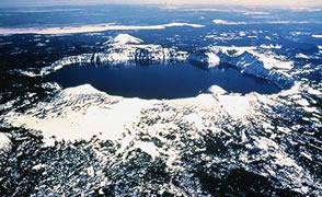 Crater Lake National park in Oregon is 100 miles from Bend and is close to the Lava Lands. A beautiful and vast lake with magical islands in the middle. Crater Lake has 44 feet of snow /year!
Crater Lake is the Deepest in the USA at 1943 feet.
Crater lake National Park Map
The Geology Bit
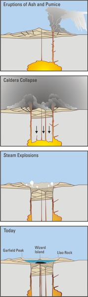 Crater Lake was formed around 7000 years ago when Mt.Mazama, a 12,000 feet high strato-volcano within the Cascades,erupted violently in a Plinian eruption. A caldera 10km wide formed when the magma chamber emptied leaving rock walls 2400m high. Ash covered an area 800,000km2. The eruption was over 40 times larger Mt.St.Helens in 1980 and expelled vast amounts of pumice and ash. Initially rhyolitic magma was erupted but as the chamber emptied more mafic ( darker material) was expelled.
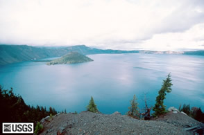
The Caldera is now filled with water and has the magically named Wizard Island (214m above water), which is a new cone starting to form. Becasue of the bare rock and climate there is very little plant and wildlife in the area. The water is very clear.
As part of the Cascades Mt.Mazama was formed due to the subduction of the Juan da Fuca plate beneath the North American plate forming the Cascade Volcanic Range. Fluids from the subducted oceanic plate have caused melting of the the mantle wedge above the plate and this melt or magma has then risen to the surface and erupted gradually forming the cone of the volcano.
USGS: Crater Lake
National Park Service: Geology of Crater Lake
To the top / Uk shop / USA shop
What to See and How to see it?
There are 2 access roads ( north and south). The southern road is open all year whereas the northern road and Crater Rim drive are closedOctober to June. The Summer visitor centre is at Rim Village on the North shore. From the visitor centre walk to Discovery Point ( 2.5 mile round trip)Nearby is the Crater lake Lodge which is open May to October. The Steel Visitor Centre at Park Headquarters is open all year except Christmas Day. and shows a short film about the volcano.
The Crater Rim Drive is 33 miles long and a challenging but popular ride for cyclists. Its high altitude and steep hills will leave you breathless but there 30 viewpoints or overlooks to rest at. Clocwise from the Park Headquarters gets the harder bits out of the way first. You can drive round too if your legs are not feelin quite so energetic!
 33 miles of the Pacific Crest Trail passes through the Park but there are 90 miles of trails in the park. Many of which are loop trails.Hiking within the Caldera is not only forbidden but very dangerous and the only lake access is at Cleetwood Cove. Smoking is forbidden on trails to cut fire risk.
There are boat trips from the only shore access at Cleetwood Cove, but there is a strenuous 1 mile trail , which descends 700ft to the lake edge ( toilets at both ends). Boats go to Wizard island and you can hike about then catch another boat back.
Link for Boat trip photos /Wizard IslandLinks
Wikipedia:Crater Lake
USGS Crater Lake:maps,photos,geology
www.crater.lake.national-park.com lots of useful information
Global Volcanism project